Category: Visualizations

New and improved US deficit visualization

New and improved US deficit visualization

| October 1, 2009 | 1 Reply

This wonderful chart, put up by Veronique de Rugy over at The American, is even better than the chart that I’ve used off and on for months to show the staggering deficit projections resulting from the Obama Administration unsustainable economic policies. As per de Rugy’s explanations, here’s what the color bars mean: the orange bars […]


Read More

Perspective on the “stimulus” disaster

Perspective on the “stimulus” disaster

| February 1, 2009 | Reply

Visualization is the key to comprehension: Hat tip to Mother, May I Sleep with Treacher? ..bruce w..

Read More

CO2 Mashup – Largely Hot Air

CO2 Mashup – Largely Hot Air

| April 8, 2008 | Reply

Click on image for greater detail Word via io9 that Purdue has put together a map of the US showing their guess of CO2 emission density. They call the System “Vulcan” and it’s interesting because there is no sensor grid for CO2. Instead Vulcan derives a guess on CO2 density from local air pollution data […]

Read More

Charting The Banking Crisis – A Boomerang Demo

Charting The Banking Crisis – A Boomerang Demo

| March 12, 2008 | 1 Reply

Anyone who has been following the financial news knows that banks and other large financial institutions are under a growing amount of strain given the misguided investments in speculative ventures over the past 5 years, including mortgages and exotic credit / investment packages. While chasing down what state a company like Merrill-Lynch might be tough, […]

Read More

Shooting Down USA 193 – My Best Guess [UPDATED]

Shooting Down USA 193 – My Best Guess [UPDATED]

| February 16, 2008 | 3 Replies

[02/19/08 – 0944 PST — Henderson here – Looks like they are going to take the shot early Thursday AM GMT, I am on the road at the moment but if I have time I will post a follow up with the new target solution in graphic glory, as well as a run down on […]

Read More

San Diego Fires post-mortem: Calit2

San Diego Fires post-mortem: Calit2

| November 7, 2007 | Reply

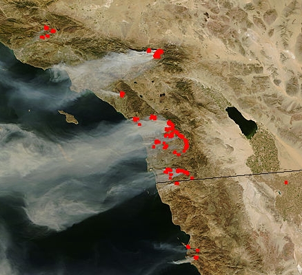
Just today I’ve had some communications with Jerry Sheehan at the California Institute for Telecommunications and Information Technology (Calit2). During the San Diego fires, they were also providing information to the public via the web, working with NASA to generate and publish satellite imagery of the fires (click on the photo and scroll down to […]

Read More

Covering The San Diego Fires – Sources And Methods

Covering The San Diego Fires – Sources And Methods

| October 30, 2007 | Reply

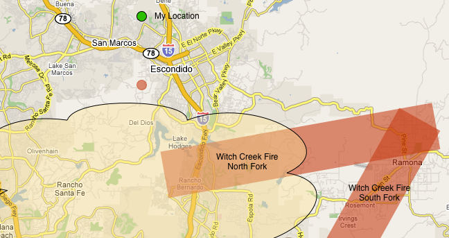
First off, I would like to thank everyone for the mountains of praise and complements on our coverage of the fires in San Diego last week. It was a large amount of work, but I think it really helped everyone, including myself, understand what was going on. Several folks have expressed interest in how and […]

Read More

Poomacha Fire Update – 29 Oct 07

Poomacha Fire Update – 29 Oct 07

| October 29, 2007 | Reply

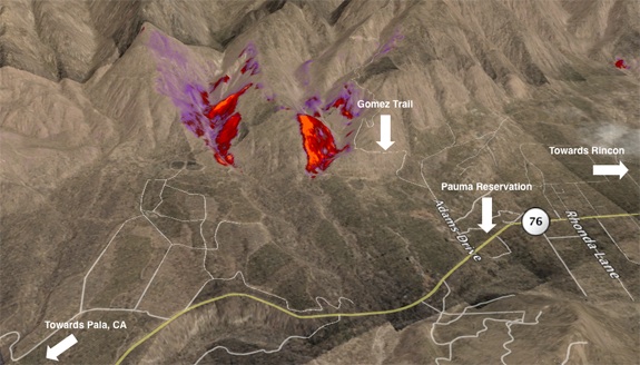
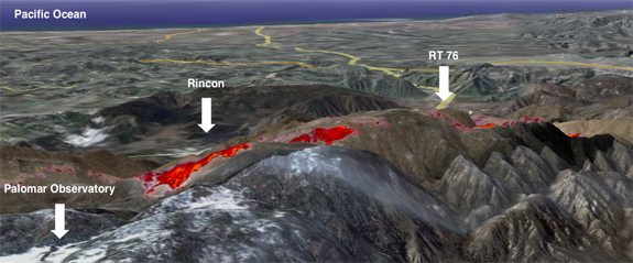
Once again fireimaging.com delivers the IR data, and you get to see the results. Poomacha continues to burn now on the East side of Palomar. I am sure everyone is quite tired of this thing already, and I know we are tired of the constant smoke plume over head. This image was created in Google […]

Read More

Poomacha Fire Update – 1220 PDT

Poomacha Fire Update – 1220 PDT

| October 27, 2007 | 2 Replies

We have some updated IR data and visualizations of the Poomacha fire burning around Palomar Mountain. First some information from the SD Union Tribune: The Poomacha fire, which has been burning parallel to the Witch Creek fire across North County, has containment lines around almost half of its 43,000 acres. It has merged again with […]

Read More

Poomacha Fire Update 1000 PDT

Poomacha Fire Update 1000 PDT

| October 26, 2007 | 1 Reply

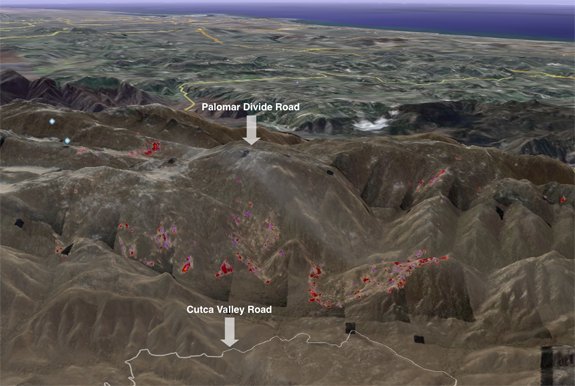
The Poomacha fire is still working hard to try and burn as much of Palomar mountain as it can, as shown in these images created from Google Earth merged once again with infra-red data from the Pacific Southwest Research Station. To create this kind of data, an aircraft flies over the fires with a special […]

Read More