Author Archive: Bruce Henderson

Bruce Henderson is a former Marine who focuses custom data mining and visualization technologies on the economy and other disasters.

rss feed Twitter

Author's Website

Harris Fire – 10:30 Update

Harris Fire – 10:30 Update

| October 24, 2007 | 1 Reply

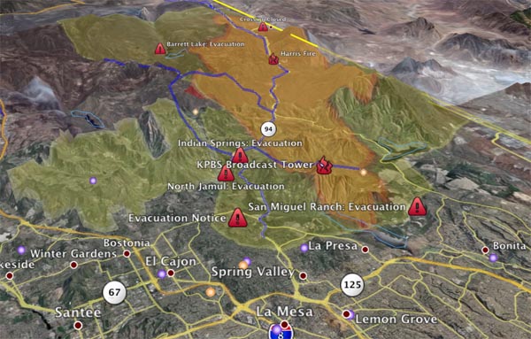
The Harris Fire is now 73,000 acres, suppression costs are at $2.5 million. There are 759 firefighters assigned. The fire was held at the edge of Chula Vista and Spring Valley. The returning onshore flow has moved the fire to the northeast threatening structures along Highway 94 from Jamul to the east and Jamacha to […]

Read More

Witch Creek Fire – Favorable Winds, The Fight Is On!

Witch Creek Fire – Favorable Winds, The Fight Is On!

| October 24, 2007 | Reply

As mentioned earlier the winds have calmed significantly and in some cases we are reading zero on the wind gauges for many cities that have been under threat of burn, or under the smoke plumes. I cannot stress enough how this fundamentally changes the fight against these fires, as it allows full deployment of air […]

Read More

Poomacha Fire Map – Our Best Guess 08:15

Poomacha Fire Map – Our Best Guess 08:15

| October 24, 2007 | 1 Reply

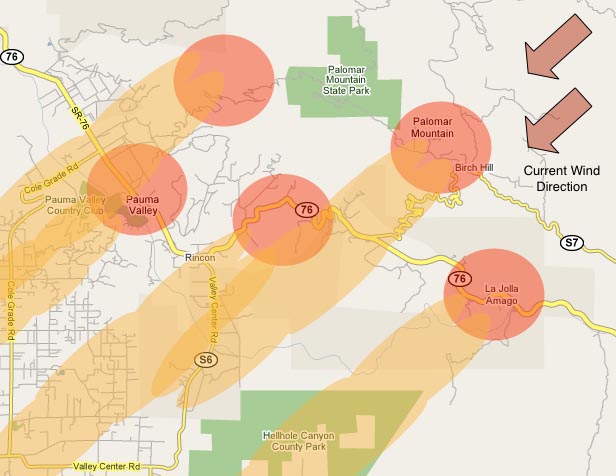
Information on the Poomacha fire is hard to come by. We have been trying since last night to find out where the burn is, and how the front of the fire is moving. There are many reports of evacuations, and given that the authorities are being very proactive about clearing people out of where the […]

Read More

Rice Canyon Fire – Horse Evacuation Site

Rice Canyon Fire – Horse Evacuation Site

| October 24, 2007 | Reply

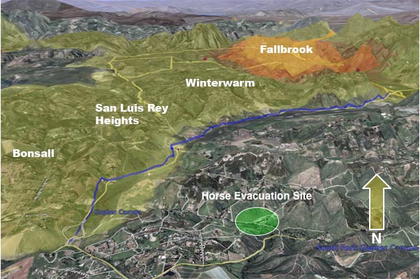
Using the KPBS overlay once again, this is a graphic that shows the position of where we moved the horses to last night relative to the Rice Canyon Fire burn area and evacuation footprint. For the moment it still seems to be safe, but I am somewhat nervous about the proximity to the evacuation areas. […]

Read More

Lake Hodges Funnel Graphic – 07:30

Lake Hodges Funnel Graphic – 07:30

| October 24, 2007 | 1 Reply

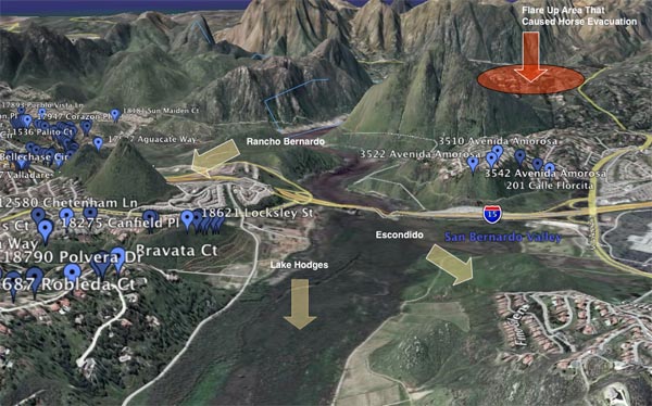
I have mentioned that on Monday the fire burned through the basin area between Rancho Bernardo and Escondido that holds Lake Hodges. With the winds blowing about 40 MPH, this area created a natural funnel and path for the fire to follow, and can largely explain the massive devastation of homes on either side of […]

Read More

Witch Creek (and North) Day #3 – 06:30 update

Witch Creek (and North) Day #3 – 06:30 update

| October 24, 2007 | Reply

Good morning everyone, and welcome back to another day. Last night the winds were mostly calm around the burn areas in sharp contrast to Sunday night and Monday night where the winds picked up speed after midnight. In my opinion this bodes quite well for chances of getting these fires bottled up or at least […]

Read More

Horse Evacuation #2 – 22:30 Update

Horse Evacuation #2 – 22:30 Update

| October 23, 2007 | 1 Reply

Earlier in the day there was a rapid evacuation of horses, including my wife’s horse, from a safe area that they had been evacuated to from the stables near Lake Wolford. A part of the Witch Creek fire, north of Lake Hodges in Escondido, flared up and began to advance on Harmony Grove, Del Dios […]

Read More

Witch Creek Fire – Rancho Bernardo Disaster Map

Witch Creek Fire – Rancho Bernardo Disaster Map

| October 23, 2007 | 1 Reply

This is not the kind of map I like to make. Today the San Diego County published a list of homes in Rancho Berndardo that were lost on Monday as the Witch Creek Fire, pushed by 50 MPH gusts, burned through the “Lake Hodges Funnel”. This map shows a grim picture: Whole streets, whole neighborhoods […]

Read More

Evacuees At Qualcomm Stadium

Evacuees At Qualcomm Stadium

| October 23, 2007 | Reply

While we wait for our site to come back up, I took a look at Matt Drudge’s page for the first time since Saturday. I saw this amazing piece of information: Civility Reigns at San Diego Stadium SAN DIEGO (AP) – Like Hurricane Katrina evacuees two years earlier in New Orleans, thousands of people rousted […]

Read More

Rice Canyon Fire – 1515 Update

Rice Canyon Fire – 1515 Update

| October 23, 2007 | Reply

This scrap of information was harvested from the comments section on the San Diego Union Tribune site: ” I just got back from a drive through part of east Fallbrook – with a police escort. It is surreal. Mission Road from the freeway to past Meagan’s bluff is on fire on both sides. Live Oak […]

Read More