Category: Maps

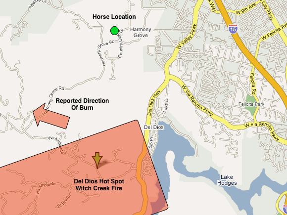
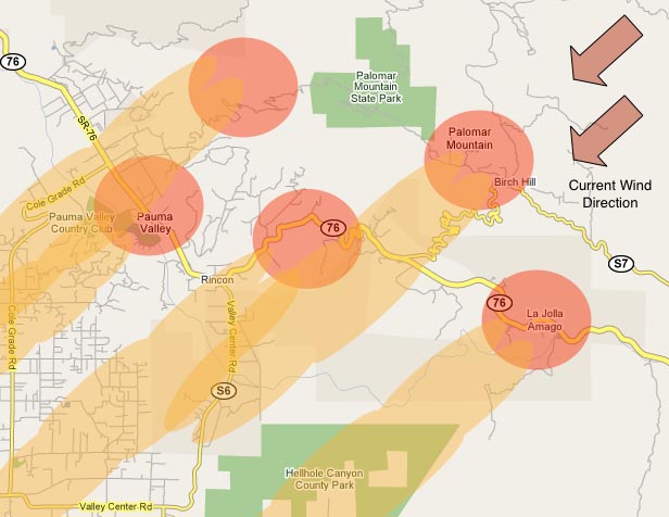
Poomacha Fire Map – Our Best Guess 08:15

Poomacha Fire Map – Our Best Guess 08:15

| October 24, 2007 | 1 Reply

Information on the Poomacha fire is hard to come by. We have been trying since last night to find out where the burn is, and how the front of the fire is moving. There are many reports of evacuations, and given that the authorities are being very proactive about clearing people out of where the […]
Read More

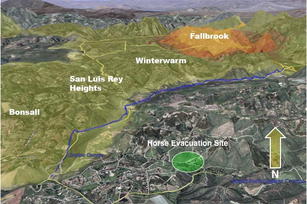
Rice Canyon Fire – Horse Evacuation Site

Rice Canyon Fire – Horse Evacuation Site

| October 24, 2007 | Reply

Using the KPBS overlay once again, this is a graphic that shows the position of where we moved the horses to last night relative to the Rice Canyon Fire burn area and evacuation footprint. For the moment it still seems to be safe, but I am somewhat nervous about the proximity to the evacuation areas. […]

Read More

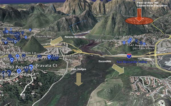
Lake Hodges Funnel Graphic – 07:30

Lake Hodges Funnel Graphic – 07:30

| October 24, 2007 | 1 Reply

I have mentioned that on Monday the fire burned through the basin area between Rancho Bernardo and Escondido that holds Lake Hodges. With the winds blowing about 40 MPH, this area created a natural funnel and path for the fire to follow, and can largely explain the massive devastation of homes on either side of […]

Read More

Harris Fire – day 3

Harris Fire – day 3

| October 24, 2007 | Reply

The Harris Fire is moving slowly, but it still is active near the Spring Valley/Lemon Grove area, as well as near the eastern outskirts of National City: Here’s the current Harris Fire report from the CALFIRE website: Harris Fire Harris Ranch Road & Hwy 94 San Diego County This fire has burned 72,000 acres and […]

Read More

Camp Pendleton (Horno) fire: I-15 now only route out of San Diego County

Camp Pendleton (Horno) fire: I-15 now only route out of San Diego County

| October 24, 2007 | Reply

If you are looking for information on the October 8th, 2008 fire in Camp Pendleton, you will find it here [Posted 0555 PDT] Yesterday I spoke at length with my son Jon, a Marine stationed at Camp Pendleton. He talked about the concerns regarding the various fires surrounding the Camp, most notably the Rice Creek […]

Read More

Harris Fire – day 2 wrapup

Harris Fire – day 2 wrapup

| October 23, 2007 | Reply

Assuming the maps put out by San Diego County are accurate, the advance of the Harris Fire has definitely slowed today. Here’s the SD County Map as of 1800 PDT today: This hasn’t changed all that much from the map that San Diego County put out at 0530 this morning. Here’s the updated information as […]

Read More

Witch Creek Fire – Rancho Bernardo Disaster Map

Witch Creek Fire – Rancho Bernardo Disaster Map

| October 23, 2007 | 1 Reply

This is not the kind of map I like to make. Today the San Diego County published a list of homes in Rancho Berndardo that were lost on Monday as the Witch Creek Fire, pushed by 50 MPH gusts, burned through the “Lake Hodges Funnel”. This map shows a grim picture: Whole streets, whole neighborhoods […]

Read More

Witch Creek Fire – 13:30 Update, Horse Evacuation In Progress

Witch Creek Fire – 13:30 Update, Horse Evacuation In Progress

| October 23, 2007 | Reply

Horse evacuation from the previous “safe spot” is now underway. There were several hundred horses at this location and adjacent. It was north of Mt. Israel road and the Elfin Forrest area on the North side of Lake Hodges. As reported earlier a offshoot that was part of the Witch Creek Fire began advancing early […]

Read More

Witch Creek Fire – 12:00 Update, Horse Evacuation #2

Witch Creek Fire – 12:00 Update, Horse Evacuation #2

| October 23, 2007 | Reply

Word has come down that where we stashed the horse is now under evacuation. Before we leave to move him to (safety?) I wanted to post a note on it. He is being moved because of the resurgent burning at the north side of Lake Hodges, near Del Dios. This area did not burn yesterday, […]

Read More

Witch Creek / Rice Canyon / Poomacha – 10:45 Update

Witch Creek / Rice Canyon / Poomacha – 10:45 Update

| October 23, 2007 | Reply

Word from the north is that the main part of Fallbrook was spared from the Rice Canyon fire. The area is still under threat, but according to a report on local news the vast majority of Fallbrook proper was not burned as some had feared. From the Fallbrook Village News ” UPDATE (8:58 am) With […]

Read More